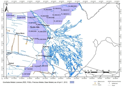
Gcwihaba - Metals (Base & Precious Metals, Platinum Group Elements and Rare Earth Elements)
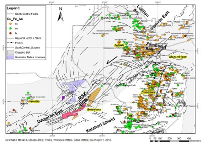
Gcwihaba has been granted 20 prospecting licenses for metals covering an area of some 15,000 square kilometers as seen on
Figure 1. The prospecting licenses are located within the nascent Okavango Rift System which is part of the East African Rift System. The Okavango Rift System takes advantage of the pre-existing structures of the northeast trending NeoProterozoic Pan African Orogenic Belt known as the Damara Belt.
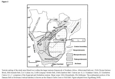
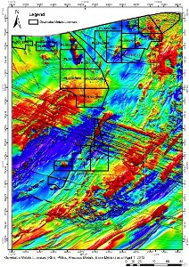
Figure 2 shows the regional tectonic setting.
The venture into metals exploration by Tsodilo (Pty) Ltd came as an off-shoot of kimberlite exploration in the southern part of the Panhandle Prospect in early 2008. It was by happenstance that sulfide mineralization was discovered whilst following up on circular magnetic anomalies which were interpreted then to be likely kimberlites. Metal prospecting licenses were then applied for and subsequently granted by the Botswana Government in December 2008.
The metals prospecting licenses are located in the northwestern part of Botswana and can be divided into three (3) main areas:
- The area bordering the Panhandle portion of the Okavango Delta - The Panhandle Prospect
- The area southwest of the Okavango Delta - The Nokaneng Prospect
- The area northeast of the Okavango Delta - The Lenyanti / Kwando Prospect
The southern part of Panhandle Prospect was an obvious target as the mineralization encountered through soil sampling was significantly elevated. The northern part of the license area was targeted purely on the basis of the structural fabric as interpreted from the aeromagnetic data while magnetic anomalies were targeted in the middle section
The Nokaneng prospect primarily targets are believed to be an extension of the Matchless Amphibolite in Namibia which hosts significant copper mineralization. The Lenyanti / Kwando Prospect is a continuation of targeting circular magnetic intrusions in the hope that they may host mineralization as discovered in the southern part of the Panhandle Prospect.
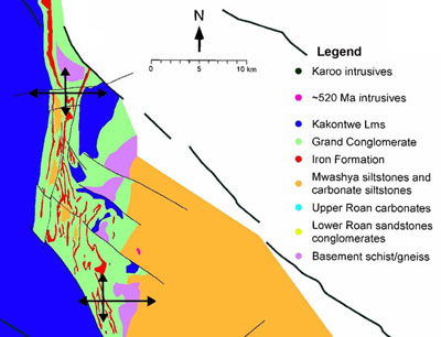
The Damara Belt is largely hidden beneath younger sediments in northwest Botswana, such that our knowledge of much of the geological and tectonical evolution relies on observations of the well-exposed lithological correlatives in Namibia. The Damara belt is known as the inland branch of the Damara Orogeny in Namibia, formed during a high angle collision of the Kalahari and Congo cratons, with the Kalahari sub-ducting northwards below the Congo Craton. The belt is estimated to have evolved within a period spanning from 580Ma to 505Ma.
The aeromagnetic data shows that the Damara structural trend is deflected from a northeast to a north to northwest trend in the area around the Panhandle Prospect. This deflection as well as our drill results indicate that this area is part of the Lufilian Arc structure. The Lufilian Arc hosts the world's largest copper-nickel-cobalt deposits in both Zambia and the Democratic Republic of Congo.
Although, the geology in the study area is mostly unexposed isolated outcrops, lithological information from boreholes and airborne geophysical data have been used by previous workers to infer the geology underlying the Kalahari sediments.
The main basement geological units are:
Phanerozoic: the clastic (mainly diamictites, shales and sandstones) and volcanic (flood basalts) Carboniferous to Jurassic Karoo sequences in the southeastern part of the delta area.
Neoproterozoic: siliclastic, shale, pelite and carbonate sequences of the Ghanzi Formation in the southeast and Damara rocks in the northwest.
Mesoproterozoic: metavolcanics and metarhyolites of the Kgwebe Formation in the southeast and granite-gneiss basement of the Kwando Complex in the central part. The Kwando Complex is not exposed; it is only recovered from borehole logs.
Palaeoproterozoic: granitic-gneiss basement of the Quangwadum Complex in the northwest.
The Mesoproterozoic Kgwebe Formation and the Neoproterozoic Ghanzi Formation rocks form what is known as the Ghanzi-Chobe Fold Belt in the southeastern part of the Delta, with the Kgwebe appearing at the core of the anticlines
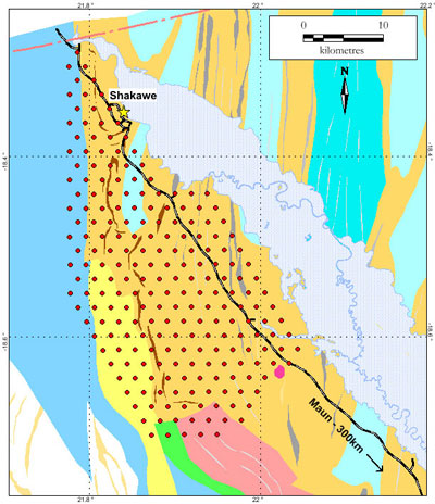
Our drilling efforts have mainly concentrated in the Panhandle Prospect in license areas PL386/2008, PL387/2008, PL388/2008 and Pl390/2008. This is primarily because of the availability of the airborne time domain electromagnetic data which is very important for locating conductive sulfide bearing structures.
Although the airborne electromagnetic (VTEM) data does cover part of our licenses in the Nokaneng Prospect, this is not very ideal since the flight lines more or less parallel the basement fabric. The drilling results can be summarized as follows:
- 44 holes were drilled in the metal licenses since 2008
- Total depth 8,148.3 meters
- 21 holes drilled in 2009, totaling 3,795 meters
- In 2008, target selection was based on magnetic anomalies
- In 2009, target selection was based on conjuctive use of airborne electromagnetic and magnetic data sets.
- 31 holes encountered significant sulphide mineralization
- Major sulphides: pyrite, pyrrhotite and minor chalcopyrite
- Pyrite concentrated towards the southern portion of the Lower Panhandle Prospect with lesser amounts of pyrrhotite and chalcopyrite.
- Pyrrhotite is concentrated towards the northern portion of the Lower Panhandle Prospect. In most holes, pyrite generally, was concentrated in the top sections and pyrrhotite below.
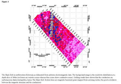
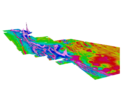
In summary, we can say that the conjunctive use of airborne electromagnetic and magnetic data sets has been very successful in drilling sulfide bearing targets. Through the use of airborne electromagnetic (VTEM)data, we have been able to delineate a belt bearing carbonaceous black shales and meta-pelites within the Damara rocks in the northwestern Botswana (see
Figure 3). It is within this belt that we encounter good sulfide mineralization within the shales and the meta-pelites.
Our drillcores bear strong similarities with those of the nickel-cobalt-copper deposits of the Kalumbila project in Zambia. Here, the mineralization is found within the pyrrhotite-pyrite bearing carbonaceous shales (
http://www.kiwara.co.uk). These shales have been correlated to the Ore Shale of the Zambian Copperbelt. The abundance of pyrrhotite in the northern part of our Lower Panhandle Prospect is particularly promising since this sulfide mineralization is often associated with economic nickel and cobalt deposits. Photos of core samples can be viewed at
/s/PhotoGallery.asp.
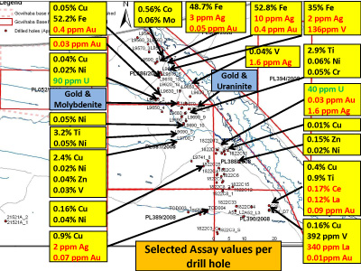
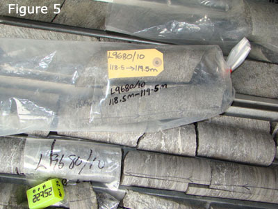
Our plan is to submit samples (see
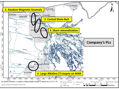
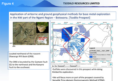
Figure 5) early 2010 for assaying in order to facilitate focused drilling. Our targets are therefore aimed at both the carbonaceous shales / metapelites and circular magnetic targets (modelled as IOCG type deposits). To this end we have an on-going high resolution ground magnetic survey (20m line spacing) in our Lower Panhandle Prospect to reveal not only to better resolve the basement structure but also possible igneous intrusions. We have so far completed 3170.9 line kilometers of magnetic data acquisition and preliminary data results indeed show that we are able to better map the basement fabric and igneous intrusions (see
Figure 4).