TORONTO, CANADA - Tsodilo Resources Limited (TSX-V:TSD) ("Tsodilo" or the "Company") is pleased to provide a summary update of its Botswana Iron Ore exploration (evaluation) activities, as well as its general Botswana exploration programs November 2013 through March 2014 (the "period"). The complete report covering the period with explanatory diagrams, photo images and tables is posted on the Company's website at:
http://www.TsodiloResources.com/i/pdf/SummaryUpdate-Apr2014.pdf.
Summary
- Twenty six (26) Iron Ore exploration (resource definition) holes were drilled during the period totaling 4,593.66 meters. Twenty (20) of these holes intersected 1,641.75 meters of Xaudum Iron Formation (XIF) mineralization.
- 3,466 XRF assay analysis were received for 61 holes in the period. From these received results there was 3,299.88 meters of XIF mineralization. Where 2,209.27 meters was Magnetite Schist (DIM and DMW*), and 968.61 meters was Magnetite BIF (MBA and MBW*). The remaining 122 meters was a new Magnetite Garnet Schist (MGS*) material.
- The global average grade for Magnetite BIF (MBA and MBW*) is 36.98% Fe; for Magnetite Schist (DIM and DMW*) is 18.51% Fe; Magnetite Garnet Schist (MGS*) is 23.38% Fe. All mineralized units within the Xaudum Iron Project are capable of producing a premium grade magnetite product of >68% Fe as discussed in the Company's Press Release of December 17, 2013 and available on the Company's website at www.TsodiloResources.com. Magnetite Garnet Schist however being a new material is being evaluated currently by Davis Tube Recovery (DTR) test work.
- There were 1,606 density measurements taken during the period, giving a global average bulk in situ density for all mineralization of 3.3 g/cm3.
- Cross sectional interpretation and geological modelling is ongoing (see Figure 4) for a NI 431-101 compliant mineral resource estimate scheduled for end Q2 2014. Holes to be included in the model are in an area called Block 1 are shown in Figure 1. Since the end of the period 13 holes remain to be drilled for inclusion in the resource estimate.
- It is an important note that the holes drilled in the Block 1 area to date (see Figure 1 and 3) only encompasses a fraction of the total potential XIF mineralization, which is believed to be in the order of 5 to 7 billion tonnes, see the press release of January 22, 2014 available on the Company's website at www.TsodiloResources.com.
- First Quantum Minerals Copper (Cu) exploration drilling continued with completion of a stratigraphic Diamond Drill (DD) line, plus continuation of the Kalahari cover sediment sampling drilling program (DD). An Airborne EM survey was also flown and completed over all of Tsodilo's metal licenses in the 4th Q of 2013, covering 16,933.6 line kilometers. The data has now been processed and has significantly enhanced geological modelling and helping in providing exploration targets.
- The high resolution ground magnetic survey over XIF continued during the period, covering 865 line kilometers (over 38 km�) and a detailed ground magnetic survey carried out over a kimberlite target in PL195/2012, covering 158 line kilometers over 4.3 km�.
*Three letter codes represent Geodomain codes, and are explained further in the complete report.
Xaudum Iron Ore Project
The Company's major exploration focus during the period was the continuation of the resource definition drilling on the Xaudum Iron Formation (XIF) magnetite iron ore project, which has an exploration target of 5 to 7 billion tonnes, see the company's press release of January 22, 2014 available on
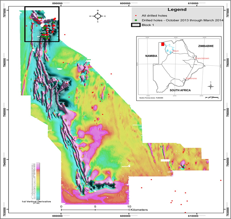
www.TsodiloResources.com. The XIF is buried below the "Kalahari cover" (Kalahari Group sediments dominantly made up of sand and calcrete) and has been delineated for exploration drilling using detailed ground magnetic surveys conducted by the Company over the area. The ground magnetic survey comprises over 18,000 line kilometers ("km") on lines 50 meters apart and covers over 1,600km². The XIF is located within two metal prospecting licenses (PL386/2008 and PL387/2008) and stretches over 35km (see Figure 1).
 Figure 1. Shows the ground magnetic data for the Xaudum Iron Formation (XIF) region, where the black line shown is the Block 1 boundary, note that Block 1 only encompasses a fraction of the total potential XIF mineralization. Red dots indicate all drilled holes and green dots show holes drilled from October 2013 through to March 2014. The diagram is filtered to show the first vertical derivative of the ground magnetic signature and the highly magnetite regions show up as high intensity.
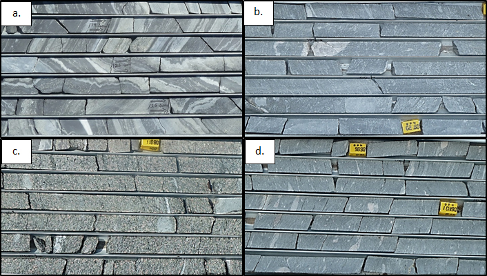
Drilling to date has confirmed that the XIF is comprised of two major materials and a third minor material:
- Magnetite Banded (BIF) material (Figure 2a). This material is Geodomained as MBA (for Magnetite Banded) when fresh, or Geodomained MBW (for Magnetite Banded Weathered) when weathered near surface (just below the Kalahari cover).
- Magnetite Schist material, also termed Magnetite Diamictite Schist (Figure 2b). This unit is Geodomained as DIM (for Diamictite Magnetic) when fresh, or Geodomained DMW (for Diamictite Magnetic Weathered) when weathered near surface. DIM has a very similar appearance to the waste Geodomain DIA (Figure 2d) however DIM has a significant proportion of magnetite and is hence magnetic, whereas and DIA does not and is non-magnetic.
- Minor unit - Magnetite Garnet Schist material (Figure 2c), is Geodomained as MGS (for Magnetite Garnet Schist).
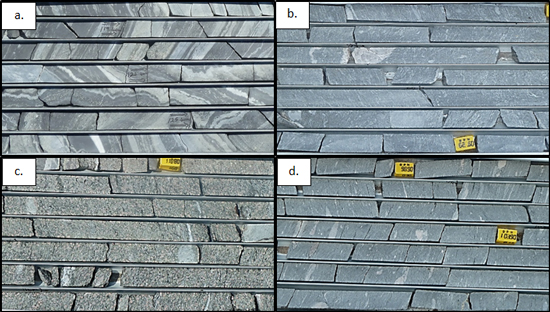 Figure 2. a. MBA (Magnetite Banded BIF) Geodomain. b. DIM (Diamictite Magnetic) Geodomain. c. MGS (Magnetite Garnet Schist) Geodomain. d. DIA (Diamictite - non-magnetic, waste material) Geodomain.
Geodomains MBA, DIM, and MGS are significantly magnetic, although MBA is more magnetic and can be considered a high grade magnetite domain, whereas DIM and MGS are less magnetic. DIM however appears to have a widespread distribution in certain areas but is rare and not seen in other areas where MBA is more dominant. DIM can also be interlayered with both MBA and MGS. In the present area of activity (shown by the green drill holes towards the south of Figure 3) DIM dominates over MBA. DIM has been intersected far more in this period than in previous Exploration Update periods, because we are drilling areas where DIM dominates over MBA. DIM is therefore considered a significant resource with it being so widespread through the XIF, although it is a lower grade resource than the MBA.
All XIF Geodomains are believed to represents metamorphosed chemical sediments that have been highly deformed, resulting in strong and well developed banding in the MBA and a foliation within the DIM and MGS. The MGS has a moderately high percentage of porphyroblastic garnets. The magnetite mineralization is more disseminated within the DIM and MGS in comparison to the banded nature of MBA.
In some locations the MBA and MGS appear to alternate within larger zones of DIM. This interlayering is suggested to represent original sedimentary layering within the mineralization zone. However in some areas this interlayering is less evident and DIM less common and MBA more dominant. This variation is tentatively postulated to be possible local facies changes within the depositional basin. Deformation, folding and potential thrusting add to the variable nature of mineralization distribution. Defining detailed stratigraphy at a local scale and true thicknesses of the XIF mineralization is therefore complicated particularly at this relatively early stage of resource drilling. The course grain-size nature within the MBA, and DIM make this material very favorable for magnetic separation and concentration. Davis Tube Recovery (DTR) results have been received for these Geodomains and prove that there is a significant potential for a very high grade product with a Fe grade of >68% Fe at good recoveries, for additional details, see press release of December 17, 2013 available on the website at
www.TsodiloResources.com. MGS is currently being evaluated by DTR.
These XIF Geodomains occur within the Grand Conglomerate horizon (which is referred to as a diamictite schist) DIA Geodomain, for Diamictite (Figure 2d). These Grand Conglomerate diamictites are a glacial origin marker horizon within the Neoproterozoic of the region.
The XIF has been identified as a Rapitan style BIF of Neoproterozoic age. Neoproterozoic BIF formations have been proposed to have formed during or in the immediate aftermath of the so called Neoproterozoic "Snowball Earth" state at that time (considered to be around 0.6-0.8 Ga in age). Other examples of Neoproterozoic BIF include the Rapitan Group in northwest Canada (18.6 billion tonnes at 47% Fe); the Yudnamutara Subgroup, Braemar Iron Formation, Australia (1.4 billion tonnes at 15.5% Fe); the Chuos Formation, Namibia (~2-3 billion tonnes at 20-28% Fe); and the Jacadigo Group, Brazil, Urucum district (~30 billion tonnes at 20-25% Fe).
Drilling
The drilling program during the period continued to focus on the northern part of the XIF magnetic signature close to the Namibian border (Figure 1). The companies' two diamond drill rigs continue to focus on evaluation resource drilling to arrive at an inferred resource (Quarter 2, 2014). Due to the strong north-south strike elongation of the Iron Formation along strike, holes are currently being drilled at 400m to 600m spacing along strike and 50m to 100m across strike.
These section lines require between 6 to 20 holes drilled to define the complexities of the formation and holes are drilled either vertical, or inclined to the east or west dependent on our knowledge of the dip of the formation. These holes are surveyed using the Reflex non-magnetic Gyroscope deviation survey tool. This tool accurately measures the direction and dip deviation of these holes within the ground, and the deviation survey results are captured in our dedicated drillhole database. The core is also orientated for accurate structural and geotechnical measurement readings (see below) using the Reflex ACT II core orientation device.
Twenty six (26) Iron exploration (resource definition) holes were drilled during the period totaling 4,593.66 meters, see Figure 3 for a map showing the holes drilled in this period. Twenty (20) of these holes intersected 1,641.75 meters of XIF mineralization as either MBA, DIM or MGS. The 6 holes that did not drill mineralization included some abandoned holes that did not reach depth and were re-drilled and some holes that only contained waste material. These holes that did not intersect Iron mineralization help define the limits of the mineralization; increase the knowledge of the regional geology and geological structure; and assist in refining future drilling targets. Further to this geotechnical logging of the rocks in these holes contributes to the knowledge of the geotechnical parameters of the waste rock surrounding the mineralization.
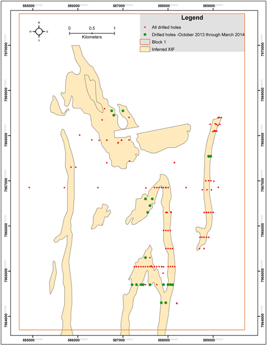 Figure 3. Map showing Ground Magnetic interpreted first derivative outline in the Block 1 area indicating where the XIF magnetite mineralization body is interpreted below the Kalahari cover. The red dots represent all holes drilled in the area and the green dots are those holes drilled during the period.
Iron Ore Post Drilling Procedures
Figure 3. Map showing Ground Magnetic interpreted first derivative outline in the Block 1 area indicating where the XIF magnetite mineralization body is interpreted below the Kalahari cover. The red dots represent all holes drilled in the area and the green dots are those holes drilled during the period.
Iron Ore Post Drilling Procedures
The orientated core is logged geo-technically on the drill site by an experienced geologist, geotechnical measurements are taken on a run by run basis for rock quality designation (RQD), material strength and fracture count. Further to this, structural measurements of alpha (α) and beta (β) angles from the orientated core are taken of the bedding, foliation, folds, fractures, joints, and other discontinuities such as veins and faults. This information is captured digitally in our drillhole database for later use in geological software and analysis, as well as for plotting on down-hole traces on geological cross sections to aid in interpretation.
Magnetic susceptibility readings are taken of the core every 20-50 cm providing instant first-order understanding of the mineralogy of the Iron bearing rocks being drilled. This information is captured in the company's drillhole database.
The entirety of the core is then logged in detail by experienced geologists using a material type percentage logging system. From this a first pass down-hole interpretation is made to assign Geodomains.
These Geodomains are then used to pick ore intervals from the core to send for chemical X-Ray Florescence (XRF) assay, plus possible mineralogical or DTR test work. The core is then cut using an Almonte Pty. automated core feed saw.
Iron Ore Sampling and QAQC (Quality Control and Quality Assurance)
The split mineralized core (half core) is sampled at 2 meter intervals and extends 20 meters on either side of the ore zones to account for variation along the ore-waste contact zone, plus to help with waste rock characterization, and define the relationship the ore has with the surrounding rock.
These 2 meter samples are measured for density using the Archimedean method of weighing dry and then weighing submerged in water. The density measurements are supplemented with QAQC check samples to ensure precision and repeatability of the density measurements. These QAQC check samples include Standards and Test Weights (5 and 10 kg) to ensure accuracy of the scale (AND GF-10K scale, precise to 0.1g) and density measurement. The accuracy of the scale has been shown to be within less than 15g. The precision of the technique has been shown to be ~0.05 g/cm3, which is the 2 stand deviations of the mean (2 s.d.) of the density standard measurements, showing that the precision of the technique is good. Density duplicates and repeats are included to check the repeatability of the technique and sampling method. The duplicates (quarter core) and repeat measurements for the period have been shown to have excellent repeatability with correlation coefficient (R) values of 0.996 and 0.988 respectively. The density QAQC results show that the applied density methodology is fit for purpose.
These 2 meter samples from the split cores are then bagged and labeled, and consigned for crushing, pulverizing (pulp creation) and XRF chemical assay to the ALS Minerals Division Geochemistry laboratory (lab) in Johannesburg, South Africa. Inserted into this sample stream and also sent to the lab for XRF assay analysis are our in house QAQC check samples. These include 3 Geostats Pty. Geostats Iron Ore Pulp (GIOP) standards that are generally matrix matched to and cover the chemical range of the XIF magnetite iron mineralization samples. These are inserted 1 in every 20 samples into the sample stream, cycling through the 3 standards. These standards check the accuracy of the XRF assay analysis. Further to this Blanks are inserted comprised of a clean white river sand (~ 99% SiO2), which was collected from a river channel near Shakawe. These Blanks are inserted into the sample stream 1 in every 20 samples and are used to check for sample to sample contamination during sample preparation at the lab. Quarter core duplicates are also taken at an interval of 1 in every 20 samples, and sent to the lab for analysis, these check our sampling process and technique for repeatability and precision.
All returned XRF assay results are checked that they pass QAQC before they are uploaded into the Company's drillhole database. This means that the GOIP standards are checked against the control limits and all have passed within acceptable limits. The blank sand is checked for contamination and none has been identified so far. The duplicates are plotted against original for precision (how close they fall to the 1:1 line) and the correlation coefficient (R) values of the duplicates for this period is 0.998 for Fe analysis, and shows no perceivable bias (all data fall close to the 1:1 line). All assays batches that included QAQC samples to date have satisfactorily passed the QAQC checks and have been uploaded into the database.
Results
XRF assays for sixty one (61) different holes totaling 3466 samples were received during the period. From these received results there was 3,299.88 meters of XIF mineralization. Where 2,209.27 meters was Magnetite Schist (DIM and DMW), and 968.61 meters was Magnetite BIF (MBA and MBW). The remaining 128 meters was Magnetite Garnet Schist (MGS). The interval weighted average grade of the Magnetite BIF (MBA and MBW), Magnetite Schist (DIM and DMW), and Magnetite Garnet Schist (MGS), for the results received this period is shown in Table 1. Also shown in Table 1 is the global interval weighted average grades for these mineralized units for comparison (where global equals all results for all holes received on the project, not just for this period). The hole by hole breakdown for the period is shown in Appendix 1. The intervals used in creating the weighted averages in Table 1 are the same as those shown in Appendix 1 and no internal waste intervals were removed. LOI refers to total LOI at 1000oC. The density values are in g/cm3, and taken from a larger data set than the assay results (see Table 2 below).
Table 1. Average Geodomain assay results for the period and globally (all results)
| Data Set |
Number of Holes |
Total Meters Intersected |
Mineralized Unit |
Fe |
SiO2 |
Al2O3 |
P |
LOI |
Average Density |
| Period |
35 |
968.61 |
Magnetite BIF (MBA and MBW) |
35.89 |
36.52 |
3.51 |
0.299 |
1.14 |
3.5 |
| Global |
79 |
4402.69 |
36.98 |
32.91 |
3.30 |
0.281 |
1.59 |
3.6 |
| Period |
38 |
2209.27 |
Magnetite Schist (DIM and DMW) |
18.75 |
52.82 |
9.50 |
0.240 |
1.15 |
3.1 |
| Global |
48 |
3010.15 |
18.51 |
46.88 |
9.26 |
0.234 |
0.88 |
3.1 |
| Period |
8 |
122 |
Magnetite Garnet Schist (MGS) |
23.78 |
50.27 |
8.84 |
0.262 |
1.27 |
3.3 |
| Global |
8 |
122 |
23.78 |
50.27 |
8.84 |
0.262 |
1.27 |
3.3 |
Table 2 shows the period and global average density for mineralized units (Magnetite BIF Geodomain MBA and MBW, Magnetite Schist Geodomain DIM and DMW, and Magnetite Garnet Schist MGS). All density figures are in g/cm
3; 2 s.d. = two standard deviations of the mean (average); Min = the minimum density value measured in the mineralized Geodomain; Max = the maximum density value measured in the mineralized Geodomain; Count = the number of measurements taken and on which the statistics are based.
Table 2. Average densities for mineralized units for the period and global
| Data Set |
Mineralized Unit |
Average |
2 s.d. |
Min |
Max |
Count |
| Period |
Magnetite BIF (MBA and MBW) |
3.5 |
0.46 |
2.9 |
4.2 |
156 |
| Global |
3.6 |
0.57 |
2.6 |
4.8 |
511 |
| Period |
Magnetite Schist (DIM and DMW) |
3.1 |
0.39 |
2.5 |
4.4 |
473 |
| Global |
3.1 |
0.35 |
2.5 |
4.4 |
631 |
| Period |
Magnetite Garnet Schist (MGS) |
3.3 |
0.34 |
3.0 |
3.7 |
38 |
| Global |
3.3 |
0.34 |
3.0 |
3.7 |
38 |
| Period |
Average of all mineralized Units |
3.2 |
0.53 |
2.5 |
4.4 |
667 |
| Global |
3.3 |
0.67 |
2.5 |
4.8 |
1180 |
As mentioned above, the density measurements are made on the same 2 meter samples that are sent away for assay, this means that there are no gaps in the density measurements record for the mineralized units. The interval chosen to take the density averages are based on the Geodomain designation, and therefore include all "short interval" internal waste and lower grade material that is included in the Geodomain interval. Therefore there is no bias towards high grade samples in these averages. This also accounts for the broad range (Min and Max) of the densities within these Geodomains and their relatively large standard deviations. Therefore, it is considered that the global averages represent the best approximation to date of the likely bulk
in-situ density of these Geodomains at a mineable scale. Density measurements will continue to be taken and these averages will improve over time along with our understanding of the geology of the project.
First Quantum Minerals Ltd
Copper (Cu) exploration drilling conducted by the Company's joint venture partner First Quantum Minerals Ltd (FQM) continued during the period. The Stratigraphic Section Line drilling program, which is a line of deep diamond drilling holes across the strike of the general geology was completed during the period. This program was designed to develop a geological model at greater depths across the project region. The total meters drilled on the Stratigraphic Section Line program during the period was 9,414.21 meters. The Kalahari Geochemistry drill program also continued through the period at a 2 km grid over the Company's PL386/2008, PL387/2008 and PL388/2008 license areas, and is now ~77% complete, and the sample batches have begun to be dispatched for assay. The Kalahari Geochemistry drilling program is designed to geochemically sample the Kalahari Group sediments, in particular the interface between the weathered bedrock and the overlying Kalahari cover sediments. The total meters of drilled on the Kalahari Geochemistry drilling program was 3,740.95 meters. Soil samples were also taken over potential target areas.
Hydro-geochemistry sampling and analysis of water samples collected from the Kalahari Geochemistry program drill holes is ongoing. Hydro-geochemistry is a relatively new exploration technique which works on the premise that groundwater will equilibrate with oxidizing mineralization at the Kalahari bedrock interface and for large scale anomalies. If this technique works, these larger anomalies or 'footprints' may be easier to see than small metal anomalies from other exploration techniques, such as vegetation sampling or sediment sampling.
There was a technical review in February which helped identify some potential target areas, which are hypothesized in 2D and 3D and ranked for drilling priority. Two drill rigs will be dedicated to testing these targets, and 1,398.22 meters has already been drilled on these targets during March. The other two drill rigs will complete the Kalahari Geochemistry program, after which time one of these drill rigs will join the target testing program.
An airborne EM and radiometric (Uranium, Thorium, Potassium and Technetium) survey was completed in October 2013 over Tsodilo's metal licenses covering 16,933.6 line kilometers. The data has been compiled and will be used as a direct and indirect targeting tool complimenting the magnetic data set in mapping the basin architecture. The radiometric data will also be useful for Tsodilo as an exploration tool in the search for radioactive mineral targets.
FQM will be starting a GyroLAG airborne gravity survey covering the same area as that which was flown by the Spectrem survey but on a 500m line spacing. This survey is expected to start at the end of April.
Geophysics
A high resolution ground magnetic survey using the company's own Cesium Vapor and Proton Precession magnetometers continued during the period, covering 865 line kilometers over 38 km2. The general strike of the iron formation is north-south; therefore lines were designed to run perpendicular to this body in the east-west direction. A line spacing of 50 meters and station spacing equivalent to one reading every 5 seconds (~ 5-6 meters) was employed to better cover some of the thinner magnetite units, averaging 100 meters in width. All data corrections which include despiking, destriping, diurnal, and tie-line leveling were performed using Geosoft software. Minimum curvature and bi-directional gridding, in conjunction with various filters and transforms, i.e. derivatives, continuations, reduction to pole, analytical signal etc. were performed to produce maps and profiles for visual and modeling purposes, see interpreted XIF from vertical derivatives in Figure 3.
Geological Modelling
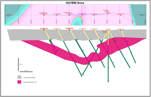
Magnetic data, drillhole Geodomains, susceptibility and assay data were integrated in Geosoft Target software to produce geologic sections. These were used to plan future holes and importantly for cross sectional interpretations as a precursor to geological modeling, Figure 4.
These cross sections are then scanned, loaded into Gocad geological modelling software, and where they are geo-referenced. The interpreted geological units are then digitized so surface wireframes can be built. Drillhole intersections are also used as control nodes so these interpreted wireframes intersect the drillhole contacts exactly to give an accurate geological model. The model are then validated against the original cross sections and between section for consistency and geological accuracy.
 Figure 4: Simplified Geological Interpretation through 1821B90 fence (bottom) and plan map (top) of filtered first vertical derivative.
Diamond Exploration
Figure 4: Simplified Geological Interpretation through 1821B90 fence (bottom) and plan map (top) of filtered first vertical derivative.
Diamond Exploration
A ground magnetic survey was carried out in Gcwihaba diamond license PL195/2012 as a follow up to the reconnaissance soil sampling carried out in May 2013. The traverse lines were oriented north-south. In order to pick up subtle kimberlite-type anomalies a line spacing of 20 m and station spacing equivalent to one reading every 3 seconds (~ 2-3 m) was employed. Initially two grids of 1km by 1km were to be covered but these were extended to cover some subtle anomalies. A total of 158 line kilometers was covered within both grids, covering an area totaling some 4.3 km2, see Figure 5. Several magnetic targets were identified and with strong possibility that these are ilmenite poor sources, based on the absence of ilmenite in the soil samples, these targets are going to be very subtle. Therefore before embarking on drilling the Company intends to cover these targets with ground gravity surveys in June in order to optimize the drill targets.
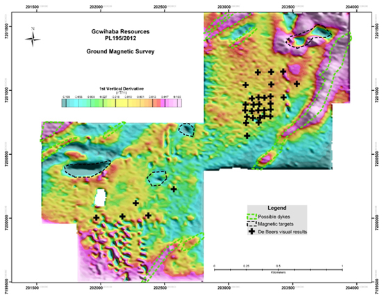 Figure 5: Ground magnetic first vertical derivative of negative magnetic anomaly (black dotted lines) inferred as a kimberlite in PL195/2012.
During the 1
st Q of 2014, Newdico (Pty) Limited was granted a two year extension of PL64/2005. Micro-diamond samples for target K11 and additional material for target K10 will be prepared for analysis and the magnetic data for target B7 will be remodelled for drilling.
Future work
The drilling in the current area will continue till early May, which is the cutoff date for the drilling to make it into the maiden NI 43-101 resource report scheduled for the end of Q2. Drilling of the Xaudum Iron Ore Project after the initial resource report will then move into a new area of drilling south of the current area. The drill spacing along the XIF will be a nominal 800 x 100-200 meters east-west across the dominant north-south strike of the mineralization
FQM is planning to fly an airborne gravity survey of the main part of the license blocks and coinciding with the Spectrem dataset in April. Their diamond drilling will continue focusing on target drilling, and the Kalahari Geochemistry program, along with the hydro-geochemical ground water sampling program.
About Tsodilo Resources Limited: Tsodilo Resources Limited is an international diamond and metals exploration company engaged in the search for economic diamond and metal deposits at its Newdico (Pty) Limited ("Newdico") and Gcwihaba Resources (Pty) Limited ("Gcwihaba") projects in northwest Botswana. The Company has a 98% stake in Newdico (851 km² under Precious Stone - diamond licenses). The Gcwihaba project area: 494 km² under Precious Stone - diamond licenses; 11,158 km2 Metal (base, precious, platinum group, and rare earth) licenses; and, 6,925 km² under Radioactive Minerals licenses is 100% held by the Company. Tsodilo manages the exploration of both the Newdico and Gcwihaba license areas. Overall supervision of the Company's exploration program is the responsibility of Dr. Mike de Wit, President and COO of the Company and a "qualified person" as such term is defined in National Instrument 43-101. Dr. de Wit has reviewed the information contained herein and approved the contents of this Press Release. Further to this, the supervision of the Xaudum Iron Ore project is the responsibility of Dr. Alistair Jeffcoate, Chief Geologist and Project Manager for the Company and a "qualified person" as such term is defined in National Instrument 43-101. Dr. Jeffcoate has also reviewed the information contained herein and approved the contents of this press release.
The Company has offices in Toronto, Canada and Gaborone and Maun, Botswana. Please visit the Company's website, www.TsodiloResources.com, for additional information and background on our projects.
National Instrument 43-101 - Standards of Disclosure for Mineral Projects, Form 43-101F1 and Companion Policy 43-101CP requires that the following disclosure be made: All references contained herein with respect to the potential quantity and grade derived by any method is at this stage of development conceptual in nature. At the present time, there has been insufficient exploration to define a mineral resource and it is uncertain if further exploration will result in the target being delineated as a mineral resource.
This press release contains forward-looking statements. All statements, other than statements of historical fact, that address activities, events or developments that the Company believes, expects or anticipates will or may occur in the future (including, without limitation, statements relating to the development of the Company's projects) are forward-looking statements. These forward-looking statements reflect the current expectations or beliefs of the Company based on information currently available to the Company. Forward-looking statements are subject to a number of risks and uncertainties that may cause the actual results of the Company to differ materially from those discussed in the forward-looking statements, and even if such actual results are realized or substantially realized, there can be no assurance that they will have the expected consequences to, or effects on the Company. Factors that could cause actual results or events to differ materially from current expectations include, among other things, changes in equity markets, political developments in Botswana and surrounding countries, changes to regulations affecting the Company's activities, uncertainties relating to the availability and costs of financing needed in the future, the uncertainties involved in interpreting exploration results and the other risks involved in the mineral exploration business. Any forward-looking statement speaks only as of the date on which it is made and, except as may be required by applicable securities laws, the Company disclaims any intent or obligation to update any forward-looking statement, whether as a result of new information, future events or results or otherwise. Although the Company believes that the assumptions inherent in the forward-looking statements are reasonable, forward-looking statements are not guarantees of future performance and accordingly undue reliance should not be put on such statements due to the inherent uncertainty therein.
The TSX Venture Exchange has not reviewed and does not accept responsibility for the adequacy or accuracy of this news release. This news release may contain assumptions, estimates, and other forward-looking statements regarding future events. Such forward-looking statements involve inherent risks and uncertainties and are subject to factors, many of which are beyond the Company's control, which may cause actual results or performance to differ materially from those currently anticipated in such statements.
FOR FURTHER INFORMATION PLEASE CONTACT:
James M. Bruchs
Chairman and Chief Executive Officer
JBruchs@TsodiloResources.com
Dr. Mike de Wit
President and Chief Operating Officer
MdeWit@TsodiloResources.com
Head Office
Telephone +1 416 572 2033
Facsimile + 1 416 987 4369
Website
http://www.TsodiloResources.com
Appendix 1
The table below sets forth the interval weighted averages for each of the 61 drillholes for which XRF assay data were received during the period. No internal waste intervals were removed and the averages are calculated as weighted averages to the assay sample interval length.
XRF assay data for the interval weighted averages for the 61 holes drilled in the period
| Hole ID |
From |
To |
Interval |
Geodomain* |
Fe |
SiO2 |
Al2O3 |
P |
LOI 1000 |
Mn |
S |
MgO |
CaO |
| 1821B80V |
74 |
146 |
72 |
DIM |
19.14 |
53.15 |
9.34 |
0.273 |
0.68 |
0.067 |
0.037 |
1.71 |
1.76 |
| L9610_11 |
266 |
302 |
36 |
DIM |
27.60 |
42.58 |
7.50 |
0.249 |
1.39 |
0.120 |
0.001 |
1.47 |
2.55 |
| L9600_10W31P2 |
96 |
98.5 |
2.5 |
DIM |
15.14 |
47.40 |
9.49 |
0.211 |
4.13 |
4.540 |
0.015 |
2.67 |
1.45 |
| 1821B83V |
50 |
76 |
26 |
DIM |
17.06 |
53.94 |
10.18 |
0.182 |
1.18 |
0.116 |
0.009 |
1.59 |
1.98 |
| 1821B120E83AK |
42 |
68 |
26 |
DIM |
14.25 |
57.95 |
11.01 |
0.148 |
0.97 |
0.126 |
0.013 |
1.58 |
1.82 |
| 1821B83E67AM |
56 |
66 |
10 |
DIM |
13.88 |
56.22 |
10.68 |
0.145 |
2.28 |
0.095 |
0.003 |
1.49 |
2.77 |
| 1821B121E91AR |
56 |
76 |
20 |
DIM |
21.69 |
50.11 |
8.95 |
0.207 |
0.98 |
0.122 |
0.013 |
1.65 |
2.38 |
| 1821B121E91AL |
92 |
152.9 |
60.9 |
DIM |
17.27 |
54.52 |
10.44 |
0.172 |
0.61 |
0.101 |
0.014 |
1.56 |
1.84 |
| L9600_10W31Q |
52 |
56.5 |
4.5 |
DIM |
15.68 |
47.15 |
9.45 |
0.211 |
5.00 |
0.629 |
0.012 |
2.54 |
5.69 |
| L9650_4 |
360 |
409.52 |
49.52 |
DIM |
15.72 |
56.33 |
10.57 |
0.233 |
0.79 |
0.092 |
0.079 |
1.90 |
1.95 |
| L9600_10W31P1 |
58 |
66 |
8 |
DIM |
17.33 |
41.53 |
9.92 |
0.232 |
5.42 |
1.690 |
0.062 |
4.18 |
5.97 |
| 1821B121E91AY |
32 |
54 |
22 |
DIM |
16.67 |
55.40 |
10.30 |
0.164 |
1.43 |
0.082 |
0.002 |
1.58 |
2.11 |
| 1821B121E91AY |
84 |
176 |
92 |
DIM |
15.83 |
56.72 |
10.50 |
0.318 |
0.54 |
0.055 |
0.008 |
1.65 |
1.47 |
| 1821B117E75AL |
46 |
76 |
30 |
DIM |
16.01 |
55.78 |
10.48 |
0.161 |
1.19 |
0.104 |
0.004 |
1.52 |
1.87 |
| 1821B120BV |
52 |
59.5 |
7.5 |
DIM |
22.78 |
48.83 |
7.75 |
0.422 |
1.91 |
0.057 |
0.011 |
1.80 |
1.76 |
| 1821B121E91AP |
34 |
48 |
14 |
DIM |
25.40 |
35.96 |
5.79 |
0.275 |
8.66 |
0.074 |
0.243 |
1.66 |
8.64 |
| 1821B121E91AQ |
66 |
86 |
20 |
DIM |
20.91 |
51.05 |
9.11 |
0.198 |
0.63 |
0.102 |
0.029 |
1.77 |
2.19 |
| 1821B120E83AM |
72 |
126 |
54 |
DIM |
16.69 |
55.35 |
10.41 |
0.166 |
0.48 |
0.106 |
0.006 |
1.52 |
1.71 |
| 1821B117E75AN |
64 |
154 |
90 |
DIM |
15.39 |
56.59 |
10.85 |
0.158 |
0.51 |
0.104 |
0.008 |
1.53 |
1.56 |
| 1821B121E91AT |
34 |
106 |
72 |
DIM |
21.08 |
49.99 |
9.04 |
0.193 |
1.16 |
0.101 |
0.009 |
1.80 |
2.05 |
| 1821B121E91AT |
158 |
178 |
20 |
DIM |
27.14 |
47.12 |
7.13 |
0.431 |
0.31 |
0.083 |
0.117 |
1.56 |
2.02 |
| 1821B120AV |
104 |
114 |
10 |
DIM |
20.99 |
49.92 |
8.39 |
0.394 |
1.17 |
0.048 |
0.018 |
1.89 |
1.74 |
| 1821B121E91AK |
52 |
82 |
30 |
DIM |
16.54 |
55.54 |
10.24 |
0.160 |
1.45 |
0.142 |
0.022 |
1.48 |
1.95 |
| 1821B121E91AS |
24 |
58 |
34 |
DIM |
21.79 |
47.89 |
8.62 |
0.202 |
2.37 |
0.111 |
0.008 |
1.69 |
2.34 |
| 1821B121E91AS |
100 |
120 |
20 |
DIM |
23.53 |
49.64 |
7.56 |
0.385 |
1.69 |
0.067 |
0.476 |
1.62 |
1.89 |
| 1821B121E91AV |
42 |
98 |
56 |
DIM |
24.59 |
47.40 |
7.84 |
0.276 |
0.44 |
0.094 |
0.006 |
1.72 |
2.24 |
| 1821B121E91AV |
134 |
156 |
22 |
DIM |
14.71 |
57.63 |
10.99 |
0.287 |
0.22 |
0.053 |
0.008 |
1.64 |
1.42 |
| 1821B121E91AW |
30 |
78 |
48 |
DIM |
23.39 |
47.91 |
8.32 |
0.209 |
0.95 |
0.102 |
0.004 |
1.67 |
2.43 |
| 1821B121E91AW |
92 |
174 |
82 |
DIM |
15.12 |
57.52 |
10.62 |
0.295 |
0.50 |
0.054 |
0.006 |
1.67 |
1.49 |
| 1821B121E91AU |
46 |
110 |
64 |
DIM |
21.56 |
50.32 |
8.78 |
0.243 |
0.64 |
0.090 |
0.007 |
1.64 |
2.22 |
| 1821B121E91AU |
124 |
144 |
20 |
DIM |
17.85 |
56.50 |
10.05 |
0.360 |
-0.56 |
0.055 |
0.008 |
1.72 |
1.53 |
| 1821B121E91AX |
12 |
82 |
70 |
DIM |
18.52 |
53.41 |
9.90 |
0.181 |
0.94 |
0.083 |
0.002 |
1.68 |
1.88 |
| 1821B121E91AX |
104 |
172.85 |
68.85 |
DIM |
14.49 |
58.02 |
10.59 |
0.295 |
0.60 |
0.052 |
0.004 |
1.56 |
1.49 |
| 1821B122W99AN |
32 |
78 |
46 |
DIM |
17.92 |
53.14 |
9.55 |
0.165 |
1.44 |
0.105 |
0.006 |
1.34 |
2.17 |
| 1821B121E91BA |
102 |
152.7 |
50.7 |
DIM |
14.02 |
59.12 |
10.53 |
0.289 |
0.56 |
0.056 |
0.005 |
1.58 |
1.39 |
| 1821B121E91AZ |
32 |
50 |
18 |
DIM |
21.44 |
49.21 |
9.08 |
0.306 |
2.24 |
0.095 |
0.003 |
1.64 |
3.28 |
| 1821B121E91AZ |
102 |
131.9 |
29.9 |
DIM |
15.43 |
56.80 |
10.88 |
0.288 |
0.65 |
0.057 |
0.073 |
1.59 |
1.30 |
| 1821B122E99AL |
66 |
136 |
70 |
DIM |
17.61 |
53.62 |
9.95 |
0.171 |
0.82 |
0.100 |
0.012 |
1.49 |
1.84 |
| 1821B122E99AL |
168 |
206 |
38 |
DIM |
17.01 |
55.55 |
10.55 |
0.168 |
0.56 |
0.120 |
0.012 |
1.58 |
1.90 |
| 1821B122E99AZ |
106 |
112 |
6 |
DIM |
24.04 |
45.87 |
7.89 |
0.220 |
0.97 |
0.139 |
0.014 |
1.80 |
2.87 |
| 1821B122E99AZ |
120 |
150 |
30 |
DIM |
18.23 |
53.80 |
9.66 |
0.170 |
1.15 |
0.082 |
0.013 |
1.62 |
2.03 |
| 1821B122E99AZ |
172 |
200 |
28 |
DIM |
16.56 |
55.33 |
10.30 |
0.168 |
1.65 |
0.078 |
0.031 |
1.68 |
2.23 |
| 1821B122E99AZ |
206 |
278 |
72 |
DIM |
16.66 |
56.22 |
10.06 |
0.343 |
0.25 |
0.055 |
0.011 |
1.66 |
1.65 |
| 1821B121E91AV |
104 |
114 |
10 |
DIM |
30.47 |
46.62 |
4.63 |
0.442 |
-0.92 |
0.047 |
0.038 |
1.68 |
1.81 |
| 1821B121E91AV |
126 |
134 |
8 |
DIM |
38.91 |
37.60 |
3.57 |
0.478 |
-1.66 |
0.037 |
0.025 |
1.40 |
1.59 |
| 1821B121E91AU |
110 |
124 |
14 |
DIM |
31.90 |
44.36 |
6.65 |
0.556 |
-1.75 |
0.054 |
0.016 |
1.59 |
1.85 |
| 1821B122E99AZ |
112 |
120 |
8 |
DIM |
28.24 |
42.38 |
7.39 |
0.248 |
0.48 |
0.114 |
0.004 |
1.76 |
2.44 |
| 1821B122E99AW |
158 |
190 |
32 |
DIM |
24.18 |
47.34 |
7.97 |
0.218 |
0.57 |
0.110 |
0.003 |
1.67 |
2.38 |
| 1821B122E99AW |
198 |
222 |
24 |
DIM |
17.69 |
54.24 |
10.38 |
0.172 |
0.56 |
0.080 |
0.005 |
1.83 |
1.95 |
| 1821B122E99AW |
244 |
298 |
54 |
DIM |
20.60 |
52.68 |
9.18 |
0.377 |
-0.05 |
0.059 |
0.012 |
1.83 |
1.96 |
| 1821B122E99AX |
140 |
228 |
88 |
DIM |
20.10 |
51.71 |
9.34 |
0.190 |
0.91 |
0.090 |
0.016 |
1.69 |
2.10 |
| 1821B122E99AX |
238 |
298 |
60 |
DIM |
16.23 |
56.14 |
10.34 |
0.352 |
0.19 |
0.055 |
0.005 |
1.69 |
1.64 |
| 1821B80V |
62 |
74 |
12 |
DMW |
18.88 |
52.80 |
9.62 |
0.276 |
0.99 |
0.075 |
0.003 |
1.79 |
2.05 |
| 1821B90V |
32 |
58.4 |
26.4 |
DMW |
16.36 |
55.81 |
9.11 |
0.142 |
3.69 |
0.115 |
0.005 |
1.62 |
3.76 |
| L9600_10E |
30 |
40 |
10 |
DMW |
14.14 |
43.18 |
7.58 |
0.174 |
8.45 |
3.175 |
0.006 |
2.44 |
8.58 |
| 1821B121E91AR |
10 |
40 |
30 |
DMW |
23.63 |
46.85 |
7.62 |
0.202 |
2.94 |
0.112 |
0.013 |
1.56 |
2.56 |
| 1821B121E91AL |
22 |
28 |
6 |
DMW |
17.85 |
50.25 |
6.49 |
0.110 |
6.89 |
0.132 |
0.006 |
1.53 |
7.59 |
| 1821B121E91AY |
8 |
32 |
24 |
DMW |
17.76 |
54.47 |
9.72 |
0.169 |
1.77 |
0.084 |
0.001 |
1.62 |
1.71 |
| 1821B120E83AL |
42 |
46 |
4 |
DMW |
17.34 |
51.10 |
9.39 |
0.170 |
3.38 |
0.094 |
0.006 |
1.66 |
3.58 |
| 1821B117E75AN |
54 |
64 |
10 |
DMW |
14.94 |
55.92 |
10.30 |
0.151 |
2.68 |
0.097 |
0.013 |
1.68 |
4.15 |
| 1821B121E91AT |
28 |
34 |
6 |
DMW |
20.14 |
47.05 |
8.25 |
0.187 |
4.98 |
0.187 |
0.010 |
1.80 |
4.25 |
| L9600_11W25O |
16 |
36.5 |
20.5 |
DMW |
19.14 |
47.03 |
8.22 |
0.227 |
3.61 |
2.223 |
0.008 |
1.98 |
3.43 |
| 1821B120AV |
66 |
104 |
38 |
DMW |
17.91 |
50.94 |
8.11 |
0.327 |
4.31 |
0.073 |
0.010 |
2.54 |
3.99 |
| 1821B121E91AK |
30 |
52 |
22 |
DMW |
17.17 |
53.17 |
9.91 |
0.169 |
2.15 |
0.087 |
0.004 |
1.50 |
2.06 |
| 1821B121E91AS |
14 |
24 |
10 |
DMW |
21.51 |
46.60 |
8.13 |
0.196 |
3.95 |
0.155 |
0.012 |
1.54 |
3.58 |
| 1821B121E91AW |
24 |
30 |
6 |
DMW |
21.39 |
47.37 |
8.29 |
0.204 |
2.98 |
0.163 |
0.004 |
1.69 |
3.30 |
| 1821B121E91AP |
10 |
34 |
24 |
DMW |
22.52 |
46.89 |
8.22 |
0.210 |
2.91 |
0.115 |
0.011 |
1.53 |
2.75 |
| 1821B122E99AK |
34 |
46 |
12 |
DMW |
26.32 |
35.50 |
4.56 |
0.223 |
6.38 |
2.667 |
0.003 |
1.53 |
7.19 |
| 1821B115E67V1 |
196 |
206.25 |
10.25 |
MBA |
42.41 |
30.78 |
1.60 |
0.331 |
1.10 |
0.515 |
0.230 |
1.29 |
2.67 |
| 1821B115E67V2 |
194 |
238 |
44 |
MBA |
35.41 |
34.18 |
4.51 |
0.288 |
1.54 |
0.949 |
0.069 |
1.94 |
3.62 |
| 1821B83V |
88 |
104 |
16 |
MBA |
32.32 |
33.65 |
5.27 |
0.303 |
2.51 |
1.939 |
0.017 |
1.64 |
3.93 |
| 1821B120E83AK |
68 |
72 |
4 |
MBA |
32.22 |
36.15 |
5.02 |
0.260 |
1.97 |
1.545 |
0.083 |
1.48 |
3.84 |
| 1821B116W78V |
52 |
114.16 |
62.16 |
MBA |
39.48 |
29.84 |
3.20 |
0.317 |
2.02 |
1.285 |
0.037 |
1.52 |
3.66 |
| 1821B111V |
90 |
98 |
8 |
MBA |
31.23 |
36.20 |
4.64 |
0.260 |
3.72 |
0.358 |
0.099 |
2.29 |
5.26 |
| 1821B121E91AR |
96 |
100 |
4 |
MBA |
36.06 |
38.60 |
4.10 |
0.549 |
0.17 |
0.054 |
0.147 |
1.31 |
1.94 |
| 1821B121E91AR |
106 |
110 |
4 |
MBA |
42.24 |
34.50 |
2.80 |
0.390 |
-1.54 |
0.147 |
0.071 |
1.13 |
1.47 |
| L9600_10W31P1 |
44 |
58 |
14 |
MBA |
35.97 |
33.06 |
3.51 |
0.315 |
2.76 |
1.184 |
0.035 |
1.63 |
4.02 |
| L9600_10W31P1 |
78 |
89.5 |
11.5 |
MBA |
32.92 |
36.42 |
4.10 |
0.291 |
2.54 |
1.496 |
0.140 |
1.47 |
3.97 |
| 1821B121E91AY |
54 |
84 |
30 |
MBA |
40.68 |
34.57 |
2.42 |
0.427 |
-0.73 |
0.044 |
0.027 |
1.38 |
2.06 |
| 1821B117E75AL |
76 |
80 |
4 |
MBA |
31.76 |
37.90 |
5.38 |
0.261 |
2.37 |
1.470 |
0.094 |
1.22 |
4.13 |
| 1821B121E91AP |
58 |
76 |
18 |
MBA |
41.34 |
34.48 |
2.59 |
0.352 |
-0.26 |
0.120 |
0.379 |
1.04 |
1.45 |
| 1821B117E75AN |
154 |
162 |
8 |
MBA |
32.96 |
35.38 |
4.43 |
0.253 |
2.53 |
1.131 |
0.117 |
1.25 |
4.39 |
| 1821B53 |
42 |
77.4 |
35.4 |
MBA |
32.31 |
33.84 |
4.27 |
0.264 |
5.64 |
0.289 |
0.016 |
2.40 |
5.18 |
| 1821B121E91AT |
106 |
112 |
6 |
MBA |
34.41 |
41.93 |
5.05 |
0.514 |
-1.57 |
0.056 |
0.018 |
1.70 |
1.82 |
| 1821B90W |
78.5 |
80 |
1.5 |
MBA |
23.07 |
50.10 |
9.85 |
0.196 |
1.19 |
0.145 |
0.007 |
2.30 |
1.64 |
| 1821B121E91AK |
82 |
86 |
4 |
MBA |
36.77 |
32.90 |
2.83 |
0.263 |
1.68 |
1.973 |
0.008 |
1.51 |
3.20 |
| 1821B121E91AS |
64 |
70 |
6 |
MBA |
35.65 |
38.37 |
2.50 |
0.453 |
3.62 |
0.066 |
0.168 |
0.80 |
1.56 |
| 1821B121E91AS |
92 |
96 |
4 |
MBA |
29.57 |
44.55 |
7.81 |
0.308 |
-1.29 |
0.157 |
0.006 |
1.80 |
1.40 |
| 1821B121E91AV |
100 |
104 |
4 |
MBA |
32.92 |
45.27 |
4.02 |
0.449 |
-1.07 |
0.041 |
0.058 |
1.63 |
1.48 |
| 1821B121E91AV |
114 |
126 |
12 |
MBA |
35.28 |
41.52 |
4.19 |
0.499 |
-1.53 |
0.045 |
0.045 |
1.55 |
1.78 |
| 1821B121E91AW |
78 |
92 |
14 |
MBA |
40.48 |
36.11 |
2.55 |
0.456 |
-0.94 |
0.034 |
0.025 |
1.38 |
1.49 |
| 1821B122W99AN |
114 |
118 |
4 |
MBA |
29.86 |
46.00 |
7.19 |
0.251 |
-0.26 |
0.157 |
0.961 |
1.37 |
1.42 |
| 1821B121E91AZ |
50 |
56 |
6 |
MBA |
44.27 |
32.93 |
1.36 |
0.363 |
-1.11 |
0.029 |
0.004 |
0.85 |
1.22 |
| 1821B122E99AL |
206 |
209.6 |
3.6 |
MBA |
42.31 |
33.95 |
1.80 |
0.331 |
-1.30 |
0.421 |
0.072 |
0.81 |
2.18 |
| 1821B122E99AZ |
100 |
106 |
6 |
MBA |
39.66 |
34.33 |
3.96 |
0.289 |
-1.45 |
0.854 |
0.014 |
1.36 |
1.80 |
| 1821B122E99AZ |
168 |
172 |
4 |
MBA |
33.60 |
40.05 |
4.60 |
0.337 |
0.39 |
0.071 |
0.020 |
1.39 |
2.82 |
| 1821B122E99AZ |
200 |
206 |
6 |
MBA |
36.48 |
38.10 |
4.14 |
0.455 |
-0.43 |
0.043 |
0.049 |
1.33 |
1.90 |
| 1821B122E99AW |
144 |
198 |
54 |
MBA |
35.59 |
38.61 |
2.62 |
0.246 |
1.02 |
0.590 |
0.017 |
1.18 |
3.47 |
| 1821B122E99AW |
222 |
244 |
22 |
MBA |
37.74 |
38.77 |
2.96 |
0.466 |
-1.13 |
0.043 |
0.046 |
1.46 |
1.84 |
| 1821B122E99AW |
262 |
272 |
10 |
MBA |
34.67 |
41.76 |
4.79 |
0.568 |
-1.58 |
0.049 |
0.043 |
1.64 |
1.97 |
| 1821B122E99AX |
130 |
140 |
10 |
MBA |
35.54 |
37.82 |
4.05 |
0.279 |
-0.03 |
0.887 |
0.057 |
1.49 |
2.49 |
| 1821B122E99AX |
228 |
238 |
10 |
MBA |
31.41 |
42.44 |
5.27 |
0.426 |
-0.35 |
0.061 |
0.004 |
1.87 |
2.20 |
| 1821B122E99AK |
46 |
94 |
48 |
MBA |
37.45 |
35.07 |
2.28 |
0.236 |
1.24 |
1.224 |
0.007 |
1.40 |
2.62 |
| 1821B122E99AQ |
68 |
80 |
12 |
MBA |
32.83 |
36.73 |
3.81 |
0.263 |
1.89 |
1.563 |
0.137 |
1.73 |
4.67 |
| 1821B122E99AQ |
92 |
104 |
12 |
MBA |
33.45 |
38.72 |
3.54 |
0.271 |
2.68 |
0.908 |
0.160 |
1.21 |
3.15 |
| 1821B122E99AQ |
164 |
178 |
14 |
MBA |
40.56 |
36.50 |
1.96 |
0.318 |
-0.14 |
0.105 |
0.204 |
0.90 |
1.68 |
| 1821B122E99AQ |
184 |
198 |
14 |
MBA |
34.60 |
42.11 |
4.14 |
0.228 |
-0.01 |
0.145 |
0.236 |
1.31 |
1.82 |
| 1821B122E99AQ |
140 |
244 |
104 |
MBA |
30.84 |
45.35 |
6.38 |
0.256 |
-1.25 |
0.139 |
0.033 |
1.79 |
1.40 |
| 1821B122E99AQ |
258 |
260 |
2 |
MBA |
35.69 |
41.00 |
4.56 |
0.276 |
-0.83 |
0.104 |
0.223 |
1.54 |
1.64 |
| 1821B116W78V |
22 |
52 |
30 |
MBW |
38.60 |
29.89 |
1.83 |
0.282 |
5.45 |
0.545 |
0.007 |
0.59 |
4.61 |
| L9600_10E |
5.8 |
30 |
24.2 |
MBW |
33.75 |
32.44 |
1.98 |
0.188 |
7.00 |
0.602 |
0.004 |
1.67 |
6.27 |
| 1821B121E91AR |
40 |
48 |
8 |
MBW |
34.51 |
37.75 |
3.89 |
0.312 |
2.89 |
0.075 |
0.011 |
0.94 |
2.82 |
| 1821B121E91AR |
52 |
56 |
4 |
MBW |
38.54 |
31.75 |
4.98 |
0.317 |
2.66 |
0.126 |
0.013 |
0.91 |
1.66 |
| L9600_10W31Q |
8 |
46 |
38 |
MBW |
40.51 |
33.26 |
2.57 |
0.240 |
2.00 |
0.348 |
0.002 |
0.52 |
1.69 |
| L9600_10W31P1 |
4 |
44 |
40 |
MBW |
36.49 |
31.93 |
2.75 |
0.260 |
5.14 |
0.489 |
0.005 |
1.34 |
3.91 |
| 1821B121E91AQ |
22 |
66 |
44 |
MBW |
33.80 |
39.48 |
3.36 |
0.321 |
2.94 |
0.058 |
0.010 |
1.03 |
2.89 |
| 1821B121E91AT |
18 |
28 |
10 |
MBW |
42.60 |
27.30 |
1.58 |
0.287 |
4.83 |
0.576 |
0.004 |
0.48 |
2.88 |
| 1821B120AV |
52 |
66 |
14 |
MBW |
37.06 |
32.00 |
3.40 |
0.229 |
5.22 |
1.961 |
0.012 |
1.43 |
1.79 |
| 1821B121E91AN |
6 |
26 |
20 |
MBW |
31.31 |
42.58 |
3.29 |
0.221 |
4.11 |
0.197 |
0.009 |
0.58 |
3.18 |
| 1821B121E91AV |
20 |
42 |
22 |
MBW |
39.27 |
29.01 |
1.28 |
0.277 |
5.77 |
0.571 |
0.027 |
0.76 |
5.10 |
| 1821B121E91AW |
8 |
24 |
16 |
MBW |
34.70 |
38.53 |
1.66 |
0.219 |
4.06 |
0.524 |
0.006 |
0.63 |
3.22 |
| 1821B121E91AU |
44 |
46 |
2 |
MBW |
40.27 |
28.31 |
1.41 |
0.298 |
5.72 |
0.704 |
0.033 |
0.98 |
3.83 |
| 1821B121E91AU |
78 |
82 |
4 |
MBW |
36.39 |
37.90 |
4.53 |
0.273 |
-1.05 |
0.074 |
0.066 |
1.06 |
1.55 |
| 1821B121E91AX |
8 |
12 |
4 |
MBW |
33.76 |
40.00 |
3.90 |
0.289 |
1.52 |
0.144 |
0.003 |
1.14 |
1.58 |
| 1821B121E91AX |
82 |
104 |
22 |
MBW |
37.54 |
40.40 |
2.12 |
0.364 |
-1.13 |
0.038 |
0.032 |
1.33 |
1.57 |
| 1821B121E91AR |
110 |
120 |
10 |
MGS |
22.98 |
50.70 |
9.01 |
0.217 |
-0.28 |
0.118 |
0.047 |
1.59 |
2.51 |
| 1821B121E91AT |
118 |
134 |
16 |
MGS |
29.62 |
46.28 |
6.55 |
0.472 |
-1.63 |
0.066 |
0.024 |
1.90 |
1.72 |
| 1821B121E91AS |
58 |
64 |
6 |
MGS |
28.08 |
45.93 |
6.45 |
0.400 |
1.03 |
0.066 |
0.022 |
1.60 |
1.69 |
| 1821B121E91AS |
96 |
100 |
4 |
MGS |
20.74 |
52.50 |
9.24 |
0.198 |
0.11 |
0.103 |
0.008 |
1.64 |
2.26 |
| 1821B121E91AU |
150 |
154 |
4 |
MGS |
21.75 |
55.40 |
9.70 |
0.370 |
-1.68 |
0.071 |
0.031 |
1.70 |
1.87 |
| 1821B122W99AN |
78 |
110 |
32 |
MGS |
20.03 |
52.93 |
10.55 |
0.169 |
-0.15 |
0.160 |
0.019 |
1.33 |
2.73 |
| 1821B121E91AZ |
56 |
62 |
6 |
MGS |
15.17 |
58.93 |
11.00 |
0.282 |
0.11 |
0.059 |
0.012 |
1.75 |
1.73 |
| 1821B122E99AL |
160 |
168 |
8 |
MGS |
18.93 |
53.30 |
10.20 |
0.179 |
0.35 |
0.112 |
0.014 |
1.61 |
2.36 |
| 1821B122E99AQ |
114 |
120 |
6 |
MGS |
26.19 |
48.03 |
8.63 |
0.233 |
-0.95 |
0.145 |
0.022 |
1.79 |
2.88 |
| 1821B122E99AQ |
198 |
228 |
30 |
MGS |
22.48 |
50.67 |
9.23 |
0.196 |
-0.25 |
0.129 |
0.010 |
1.64 |
2.35 |
*DIM - Magnetite Schist
DMW - Weathered Magnetite Schist
MBA - Magnetite Banded (BIF)
MBW - Weathered Magnetite Banded (BIF)
MGS - Magnetite Garnet Schist |
View the release in PDF format: