TORONTO, ONTARIO - Oct. 13, 2004 - Tsodilo Resources Limited (TSX Venture Exchange: TSD) is pleased to announce the commencement of a drilling program in Botswana and to provide the following update on its exploration activities and plans for the Company's current Ngamiland diamond exploration program.
There are three main thrusts to the drilling program:
- Kimberlite A37 - further evaluation
- Explore high-priority, identified kimberlite targets
- Explore a satellite image feature that may reflect the location of an interpreted alluvial paleochannel
A37 Kimberlite
Vertical Reverse circulation drilling of this target commenced on October 8, 2004. The first hole, 37-7, intersected an upward-fining sequence of crater facies kimberlitic sediments underlying sandy overburden of the Kalahari Formation at 41 meters. This crater sequence is dominated by fragments of fine-grained macrocryst-bearing kimberlite with a relatively low country-rock xenolith content (approximately 10 to 15 %) in the depth interval 81-90 meters, and extends to a depth of 105m after which the drill hole intersected a zone dominated by dolomite and phyllite. The hole was terminated at 116 meters in this bedrock.
Drill target A37-8 was also tested with a vertical reverse circulation drill hole. Beneath a 42 meter thickness of Kalahari sediment and calcretes, the hole intersected an upward fining sedimentary sequence, with a thick basal coarse fragmental unit, carrying subrounded to angular wallrock fragments, grading upwards into coarse sandstones and overlying shales and muds, typical of the sequences that characterize crater lake infill. Country rock dolomite and phyllite form the floor to this sequence at a depth of 152 meters. The hole was terminated at 156 meters in this bedrock on October 13, 2004.
The Company achieved its objective of obtaining coarser-grained samples with a higher probability of carrying micro-diamonds than previous drillhole samples from the A37 body.
Drill cuttings from these two holes will be sent to Mineral-Logic in Cape Town, South Africa, for integrated petrographic and indicator-mineral analysis and if warranted to the Saskatchewan Research Council for micro-diamond analysis and interpretation. The results will be released on completion of the processing.
Our initial estimate of the size of the A37 kimberlite crater is some 1 000m in length by 500m to 600m in width with a strong probability of an extension to the east of this - we conservatively estimate the kimberlite and crater sediments to extend over a 115 hectare surface area. In total 8 holes (6 previously) have now been drilled at A37 for a total of 1,010 meters. While further drilling will be required to delineate this body with greater accuracy, our interpretation of the results suggest that A37 would be the second or third largest kimberlite discovered in the Republic of Botswana to date. The Republic of Botswana is the largest producer of diamonds, by value, in the world.
High Priority Identified Targets
Eight drillholes are planned to investigate associated magnetic, gravity and kimberlitic indicator mineral (KIMs) anomalies within the known Nxau Nxau cluster.
The drilling program will also include several targets outside of the Nxau Nxau cluster; one in the Gcwihaba licences where a sodium-rich eclogitic (diamond inclusion) garnet was found in a loam sample over an airborne magnetic anomaly; and, one hole into each of three G9 peridotitic kimberlitic garnet anomalies over magnetic features in the Guma area (three out of four of these results were fully reported in our press release dated Wednesday, August 4, 2004). These latter four targets are currently the subject of detailed gravity and magnetic surveys to further define the drill targets. Kimberlitic ilmenites and garnets were also recovered in the Guma area as a result of a 5 x 5 kilometer regional grid sampling campaign and previous direct sampling over target magnetic anomalies.
There are 48 loam samples currently being analysed for indicator minerals and these results should be reported within two weeks. Any additional indicator mineral anomalies from these samples will also be investigated by detailed gravity and magnetic surveys before drilling sites are selected.
Satellite image feature - possible paleochannels
Tsodilo recently acquired high resolution satellite radar and false-colour imagery to obtain evidence for the location and distribution of pre-Kalahari-aged alluvial channels. These can be viewed on our website www.tsodiloresources.com, in the "Imagery" section. One of our primary motivations for exploring the Newdico and Gcwihaba licence areas is the fact that macro-diamonds and G10 garnets occur in secondary alluvial deposits of the Kalahari basin at Tsumkwe and Omatako in Namibia. The location and distribution of the paleochannels that transported these secondary alluvial deposits will allow us to follow the trail of indicator minerals back to their primary source, which we believe lies within our licence areas.
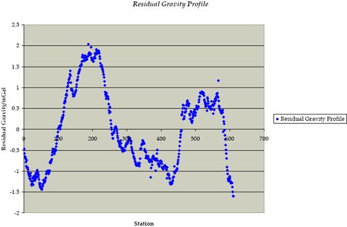
The Consultant commissioned to perform the gravity survey along the border has completed his initial line of survey along a 30km portion of the border. This line straddles a prominent linear satellite image feature (see, the area indicated on the satellite imagery as Border gravity points). The gravity survey shows that this image feature is coincident with a major gravity low (between stations 200 and 460m - see the gravity profile below), which the geophysical consultant interprets to reflect a major pre-Kalahari valley. A further gravity low (between stations 0 - 100) has been interpreted to reflect a second channel to the south. After completion of drilling on the targets in the Nxau Nxau area, we will begin to drill in these features to determine the actual presence of these paleochannels and any associated alluvial sediments. If these sediments offer encouragement, we will commence further gravity traverses across the interpreted course of these paleochannels, and continue to follow-up with drilling to confirm their location and whether the associated alluvial sediments carry kimberlite indicator minerals.
Residual Gravity Profile
http://www.tsodiloresources.com/i/misc/residual.gif
Tsodilo Resources is an international diamond exploration company engaged in the search for economic kimberlites at its Newdico and Gcwihaba projects in northwest Botswana. Tsodilo has a 75% stake in Newdico while Trans Hex Group, a South African diamond mining and marketing company, holds the remaining 25%. The southern Gcwihaba Project area is 100% held by Tsodilo subsidiary Gcwihaba Resources. Tsodilo manages the exploration of both licence areas. The design and conduct of the Company's exploration program is the responsibility of Peter Walker, a professional geologist registered with the South African Council for Natural Scientific Professions.
The TSX Venture Exchange has not reviewed and does not accept responsibility for the adequacy or accuracy of this news release. This news release may contain assumptions, estimates, and other forward-looking statements regarding future events. Such forward-looking statements involve inherent risks and uncertainties and are subject to factors, many of which are beyond the Company's control, that may cause actual results or performance to differ materially from those currently anticipated in such statements.
-30-
FOR FURTHER INFORMATION PLEASE CONTACT:
Tsodilo Resources Limited
James M. Bruchs
President and Chief Executive Officer
(416) 800-4214
(416) 572-4164 (FAX)
E-Mail JBruchs@TsodiloResources.com
or
Tsodilo Resources Limited
Peter W.A. Walker
Vice President, Exploration
(416) 800-4214
(416) 572-4164 (FAX)
E-Mail PWalker@TsodiloResources.com